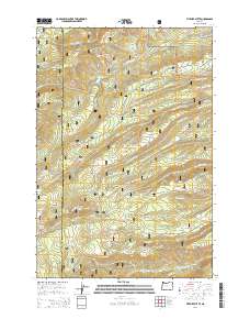
2014 Map of Fivemile Butte
USGS Topo · Published 2014About this map
Mount Hood National Forest dominates this section of north-central Oregon, where the landscape is defined by the complex drainage systems of the Cascade Range. Numerous springs, such as Pollywog Spring, Bascom Spring, and Jacket Springs, feed the numerous creeks that carve deep through the terrain. The map captures an area characterized by forestry and watershed management, centered on the prominent Fivemile Butte. This topography reveals the extensive network of forest development and service roads, including Brooks Meadow Rd and Fivemile Crossing Rd, which provide access to high-elevation features like Mount Hood Flat. The inclusion of Camp Baldwin Lake and Crow Creek Reservoir highlights the importance of water storage in the region, while landmarks like Bottle Prairie and Rail Hollow point to the varied land use and local nomenclature of this high-country environment.
Find a feature on this map
51 named features on this map. Tap any name to fly to it.
Don’t see what you’re looking for? This feature index may not catch every label — zoom into the map to look around manually.
Map Details
Editions of this 2014 Fivemile Butte Map
This is the sole edition of this map. No revisions or reprints were ever made.
Other maps of this area

1924 · Mount Hood
USGS Topo · 1:125,000

1926 · Hood River
USGS Topo · 1:125,000

1927 · Mount Hood
USGS Topo · 1:125,000

1929 · Hood River
USGS Topo · 1:125,000

1930 · Dufur
USGS Topo · 1:125,000

1934 · Dufur
USGS Topo · 1:125,000

1934 · The Dalles
USGS Topo · 1:125,000

1953 · The Dalles
USGS Topo · 1:250,000

1956 · The Dalles
USGS Topo · 1:250,000

1957 · The Dalles
USGS Topo · 1:250,000