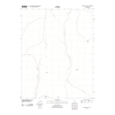
2011 Map of Fivemile Valley
USGS Topo · Published 2011About this map
Paria and its surrounding canyonlands are documented here just after the turn of the twenty-first century, showing a landscape defined by the winding course of the Paria River. The terrain transitions from the broad Brigham Plains to the sheltered Fivemile Valley, where historic activity is marked by the Hattie Green Mine. This area of Kane County relies on a network of unpaved routes, including Old County Rd and the long stretch of Cottonwood Canyon Rd, which tracks the drainage of Cottonwood Creek. Local water sources like Five Mile Spring provide critical points of interest in an otherwise arid geography characterized by natural features such as Rock House Cove and Catstair Canyon. The map reveals the intricate drainage patterns of Sand Gulch and West Cove, illustrating how the physical environment has dictated the placement of roads and resource extraction sites in this part of southern Utah.
Find a feature on this map
13 named features on this map. Tap any name to fly to it.
Don’t see what you’re looking for? This feature index may not catch every label — zoom into the map to look around manually.
Map Details
Editions of this 2011 Fivemile Valley Map
This is the sole edition of this map. No revisions or reprints were ever made.
Other maps of this area

1886 · Kanab
USGS Topo · 1:250,000

1886 · Escalante
USGS Topo · 1:250,000

1953 · Cedar City
USGS Topo · 1:250,000

1954 · Buckskin Gulch NE
USGS Topo · 1:24,000

1954 · Buckskin Gulch SE
USGS Topo · 1:24,000

1954 · Paria NW
USGS Topo · 1:24,000
1954 · Paria SW
USGS Topo · 1:24,000

1954 · Buckskin Gulch
USGS Topo · 1:62,500

1954 · Paria
USGS Topo · 1:62,500

1955 · The Cockscob SW
USGS Topo · 1:24,000