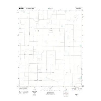
2012 Map of Flagg
USGS Topo · Published 2012About this map
Agricultural development and livestock operations define this section of Castro County, where the landscape is organized by a strict grid of county roads and ranching infrastructure. Flagg and Big Square stand as the primary community focal points in an area dominated by large-scale farming. The presence of the Cadillac Feedyard and the Ott Farms Airport reflects the specialized agricultural economy of the Texas Panhandle, where air transport and industrial cattle feeding are integrated into rural life. Transport across the plains is facilitated by a network of state and local routes, including Fm-1055, Ranch Road 1524, and Ranch Road 145. This survey captures the region's character as a productive agricultural heartland, marked by playa lakes and irrigation patterns that sustain the local economy.
Find a feature on this map
20 named features on this map. Tap any name to fly to it.
Don’t see what you’re looking for? This feature index may not catch every label — zoom into the map to look around manually.
Map Details
Editions of this 2012 Flagg Map
This is the sole edition of this map. No revisions or reprints were ever made.
Other maps of this area

1954 · Clovis
USGS Topo · 1:250,000

1958 · Clovis
USGS Topo · 1:250,000

1962 · Dodd NE
USGS Topo · 1:24,000

1963 · Flagg
USGS Topo · 1:24,000

1963 · Lazbuddie
USGS Topo · 1:24,000

1963 · Dodd SE
USGS Topo · 1:24,000

1963 · Dodd
USGS Topo · 1:24,000
1963 · Lazbuddie SE
USGS Topo · 1:24,000

1965 · Dimmitt
USGS Topo · 1:24,000

1965 · Dimmitt SW
USGS Topo · 1:24,000