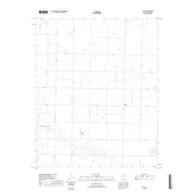
2019 Map of Flagg
USGS Topo · Published 2019About this map
Running Water Draw carves a distinct path across the southwestern corner of this West Texas landscape, providing a rare topographical break in the High Plains. The small community of Flagg sits at the intersection of FM 1055 and Co RD 623, serving as a central hub for the surrounding agricultural tracts. This section of Castro County is defined by a strict grid of county roads, such as Co Rd 505 and Co RD 625, which organize the vast ranching and farming operations characteristic of the region. The presence of Ott Farms Airport underscores the importance of aerial support for local agriculture. Numerous small depressions and seasonal wetlands are scattered throughout the quadrangle, illustrating the playa lake patterns common to this part of the Panhandle.
Find a feature on this map
19 named features on this map. Tap any name to fly to it.
Don’t see what you’re looking for? This feature index may not catch every label — zoom into the map to look around manually.
Map Details
Editions of this 2019 Flagg Map
This is the sole edition of this map. No revisions or reprints were ever made.
Other maps of this area

1954 · Clovis
USGS Topo · 1:250,000

1958 · Clovis
USGS Topo · 1:250,000

1962 · Dodd NE
USGS Topo · 1:24,000

1963 · Flagg
USGS Topo · 1:24,000

1963 · Lazbuddie
USGS Topo · 1:24,000

1963 · Dodd SE
USGS Topo · 1:24,000

1963 · Dodd
USGS Topo · 1:24,000
1963 · Lazbuddie SE
USGS Topo · 1:24,000

1965 · Dimmitt
USGS Topo · 1:24,000

1965 · Dimmitt SW
USGS Topo · 1:24,000