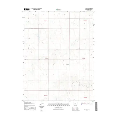
2016 Map of Flagler NE
USGS Topo · Published 2016About this map
Hell Cr winds through the northern portion of this Kit Carson County landscape, carving a subtle drainage pattern into the high plains terrain. This 2016 survey emphasizes the systematic rural grid of the Public Land Survey System, which remains the primary organizing force for human activity and movement. The map captures a largely agricultural expanse where movement is dictated by a network of numbered county roads, including Co Rd HH and Co Rd FF, which segment the landscape into precise sections. In the southern reach of the quadrangle, Buffalo Creek and its smaller tributary labeled Buffalo Cr provide the principal topographic relief. These watercourses, though seasonal, have historically shaped the placement of roads and homesteads in this part of eastern Colorado, offering a clear view of the relationship between natural hydrology and the persistent rectangular survey grid.
Find a feature on this map
21 named features on this map. Tap any name to fly to it.
Don’t see what you’re looking for? This feature index may not catch every label — zoom into the map to look around manually.
Map Details
Editions of this 2016 Flagler NE Map
This is the sole edition of this map. No revisions or reprints were ever made.
Other maps of this area

1954 · Limon
USGS Topo · 1:250,000

1957 · Limon
USGS Topo · 1:250,000

1958 · Limon
USGS Topo · 1:250,000

1977 · Thurman
USGS Topo · 1:24,000

1977 · Anton SE
USGS Topo · 1:24,000

1977 · Cope SW
USGS Topo · 1:24,000

1979 · Flagler SW
USGS Topo · 1:24,000

1979 · Flagler NW
USGS Topo · 1:24,000

1979 · Flagler
USGS Topo · 1:24,000
1979 · Flagler NE
USGS Topo · 1:24,000