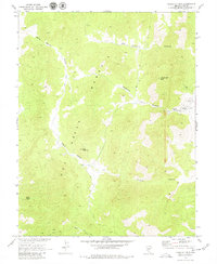
1968 Map of Flagstaff Mtn.
USGS Topo · Published 1979About this map
The Keystone (Site) occupies a prominent position within the Hot Creek Range, reflecting the area's legacy of high-desert prospecting and resource extraction. This late-1960s survey, conducted in cooperation with the Atomic Energy Commission, documents a landscape shaped by both natural relief and human industry. Evidence of early activity is visible in the presence of kilns near Tybo Creek and a prospect north of Old Dominion Canyon.
Find a feature on this map
17 named features on this map. Tap any name to fly to it.
Don’t see what you’re looking for? This feature index may not catch every label — zoom into the map to look around manually.
Map Details
Editions of this 1968 Flagstaff Mtn. Map
2 editions found
Other maps of this area

1956 · Tonopah
USGS Topo · 1:250,000

1959 · Tonopah
USGS Topo · 1:250,000

1962 · Tonopah
USGS Topo · 1:250,000

1967 · Blue Jay Spring
USGS Topo · 1:24,000

1967 · Tybo SE
USGS Topo · 1:24,000

1968 · Tybo
USGS Topo · 1:62,500

1968 · Morey Peak
USGS Topo · 1:62,500
1968 · Flagstaff Mtn.
USGS Topo · 1:24,000
1968 · Hobble Canyon
USGS Topo · 1:24,000
1968 · Tybo
USGS Topo · 1:24,000