
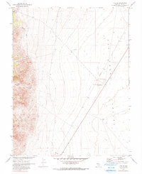
1967 Map of Tybo SE
USGS Topo · Published 1973About this map
Central Nevada Test Site Base Camp stands as a significant marker in this arid landscape, a site mapped in cooperation with the Atomic Energy Commission during a period of intense federal activity in the desert. The terrain transitions from the high, carved walls of Fairbanks Canyon, Red Rock Canyon, and Music Canyon in the west down toward the broad expanse of Hot Creek Valley. Sparse human presence is evidenced by isolated water sources like Pedro Well, Tybo Well, and Fallini Well, essential outposts for ranching or mining operations in the region. Near the northern boundary, a Cem and the course of Tybo Creek indicate the remnants of earlier local habitation, while a Landing Strip and Sewage Disposal Pond serve the base camp's modern operations.
Find a feature on this map
13 named features on this map. Tap any name to fly to it.
Don’t see what you’re looking for? This feature index may not catch every label — zoom into the map to look around manually.
Map Details
Editions of this 1967 Tybo SE Map
2 editions found
Other maps of this area

1956 · Tonopah
USGS Topo · 1:250,000

1959 · Tonopah
USGS Topo · 1:250,000

1962 · Tonopah
USGS Topo · 1:250,000

1967 · Lunar Crater
USGS Topo · 1:62,500

1967 · Blue Jay Spring
USGS Topo · 1:24,000

1967 · Buckwheat Rim
USGS Topo · 1:24,000

1967 · Palisade Mesa
USGS Topo · 1:24,000

1968 · Tybo
USGS Topo · 1:62,500

1968 · Warm Springs
USGS Topo · 1:62,500
1968 · Reveille
USGS Topo · 1:62,500