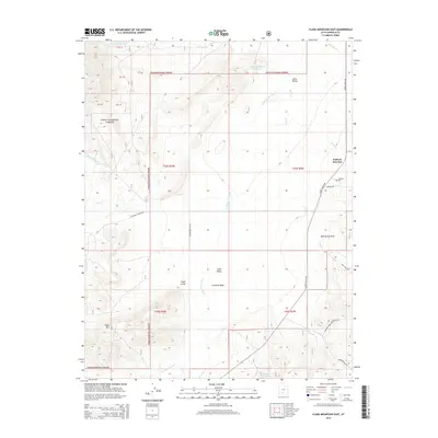
2014 Map of Flake Mountain East
USGS Topo · Published 2014About this map
Johns Valley dominates this high-altitude landscape within the Dixie National Forest, where the topography transitions from the alluvial plains of Cameron Wash to the prominent peak of Flake Mtn. The map documents the vital water management systems essential to this arid region, including Reynolds Spring Reservoir and Cameron Wash Reservoir No 1. Significant for genealogical research, the area around Widtsoe Junction includes the Widtsoe Cem, a key marker for the history of settlement in this part of Garfield County. The drainage network is clearly defined by the E Fork Sevier River and its various tributaries such as Sweetwater Cr and Clay Cr, illustrating how the hydrology dictated the placement of early roads like John's Valley Rd and Toms Best Spring Rd.
Find a feature on this map
36 named features on this map. Tap any name to fly to it.
Don’t see what you’re looking for? This feature index may not catch every label — zoom into the map to look around manually.
Map Details
Editions of this 2014 Flake Mountain East Map
This is the sole edition of this map. No revisions or reprints were ever made.
Other maps of this area

1886 · Kanab
USGS Topo · 1:250,000

1886 · Escalante
USGS Topo · 1:250,000

1953 · Cedar City
USGS Topo · 1:250,000

1956 · Escalante
USGS Topo · 1:250,000

1958 · Cedar City
USGS Topo · 1:250,000

1960 · Escalante
USGS Topo · 1:250,000

1962 · Cedar City
USGS Topo · 1:250,000
1964 · Grass Lakes
USGS Topo · 1:24,000
1964 · Sweetwater Creek
USGS Topo · 1:24,000
1964 · Pine Lake
USGS Topo · 1:24,000