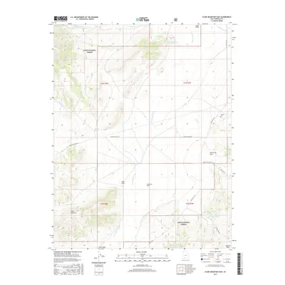
2017 Map of Flake Mountain East
USGS Topo · Published 2017About this map
Johns Valley dominates this high-altitude landscape within the Dixie National Forest, serving as a broad corridor for the north-flowing E Fork Sevier River. The terrain is characterized by complex hydrology, featuring numerous seasonal watercourses like Mud Spring Draw and Cameron Wash, which feeds into the Cameron Wash Reservoir Number 1. Significant elevation changes are marked by Flake Mountain and the distinct depression of Flake Swale. Cultural history is anchored by the Widtsoe Cem along Johns Valley Rd, a point of interest for genealogists tracing local families. The map also documents recreational and agricultural infrastructure, including the Great Western ATV Trail, Reynolds Spring Reservoir, and isolated water sources such as Tom Best Spring and Dipping Vat Spring.
Find a feature on this map
31 named features on this map. Tap any name to fly to it.
Don’t see what you’re looking for? This feature index may not catch every label — zoom into the map to look around manually.
Map Details
Editions of this 2017 Flake Mountain East Map
This is the sole edition of this map. No revisions or reprints were ever made.
Other maps of this area

1886 · Kanab
USGS Topo · 1:250,000

1886 · Escalante
USGS Topo · 1:250,000

1953 · Cedar City
USGS Topo · 1:250,000

1956 · Escalante
USGS Topo · 1:250,000

1958 · Cedar City
USGS Topo · 1:250,000

1960 · Escalante
USGS Topo · 1:250,000

1962 · Cedar City
USGS Topo · 1:250,000
1964 · Grass Lakes
USGS Topo · 1:24,000
1964 · Sweetwater Creek
USGS Topo · 1:24,000
1964 · Pine Lake
USGS Topo · 1:24,000