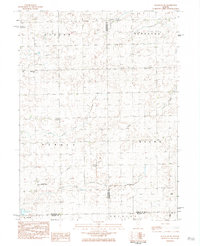
1983 Map of Flanagan SW
USGS Topo · Published 1984About this map
El Paso sits at the southwestern edge of this agricultural landscape, where the prairie is defined by the headwaters of the Panther Creek system. The map reveals a rural economy supported by local aviation, noted by the presence of the Pfister Landing Strip and Janssen Landing Strip. Along the northern reaches, the Baughman Cem provides a point of interest for genealogists, while a Historical Monument stands alone in the central fields of Panola township. The terrain is divided into tidy sections across Minonk, Nebraska, and Waldo, illustrating the enduring township and range system that organized this part of Central Illinois. Water management is evident through the Gaging Station on the East Branch Panther Creek and the localized Sewage Disposal Ponds near the township borders.
Find a feature on this map
22 named features on this map. Tap any name to fly to it.
Don’t see what you’re looking for? This feature index may not catch every label — zoom into the map to look around manually.
Map Details
Editions of this 1983 Flanagan SW Map
This is the sole edition of this map. No revisions or reprints were ever made.
Other maps of this area

1926 · Normal
USGS Topo · 1:62,500

1927 · Danvers
USGS Topo · 1:62,500

1930 · Danvers
USGS Topo · 1:62,500

1930 · Normal
USGS Topo · 1:62,500

1955 · Minonk
USGS Topo · 1:62,500

1958 · Flanagan
USGS Topo · 1:62,500

1958 · Peoria
USGS Topo · 1:250,000

1961 · Peoria
USGS Topo · 1:250,000

1963 · Peoria
USGS Topo · 1:250,000
1970 · El Paso
USGS Topo · 1:24,000