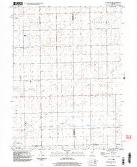
1999 Map of Flanagan SW
USGS Topo · Published 2003About this map
The agricultural plains of Woodford and Livingston Counties are defined by a network of drainage ways and township boundaries as they appeared at the close of the millennium. The terrain is bisected by several key watercourses, including Short Point Creek in the north and the East Branch Panther Creek winding through the southern sections. Notable for genealogists is the Baughman Cem located near the boundary between Minonk and Panola townships. Small-scale aviation is represented by private facilities like the Janssen Landing Strip and Pfister Landing Strip. While the town of El Paso occupies the southwestern corner, the landscape is primarily rural, marked by utility infrastructure like a prominent Pipeline and a Radio Tower. Cultural markers, such as a Historical Monument near Little Panther Creek, offer physical points of interest for local historians studying the settlement patterns of Nebraska, Waldo, and Gridley townships.
Find a feature on this map
22 named features on this map. Tap any name to fly to it.
Don’t see what you’re looking for? This feature index may not catch every label — zoom into the map to look around manually.
Map Details
Editions of this 1999 Flanagan SW Map
This is the sole edition of this map. No revisions or reprints were ever made.
Other maps of this area

1926 · Normal
USGS Topo · 1:62,500

1927 · Danvers
USGS Topo · 1:62,500

1930 · Danvers
USGS Topo · 1:62,500

1930 · Normal
USGS Topo · 1:62,500

1955 · Minonk
USGS Topo · 1:62,500

1958 · Flanagan
USGS Topo · 1:62,500

1958 · Peoria
USGS Topo · 1:250,000

1961 · Peoria
USGS Topo · 1:250,000

1963 · Peoria
USGS Topo · 1:250,000
1970 · El Paso
USGS Topo · 1:24,000