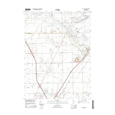
2014 Map of Flat Rock
USGS Topo · Published 2014About this map
The Huron River serves as the central geographic feature of this 2014 survey, meandering through the communities of Flat Rock, Rockwood, and South Rockwood. The landscape is a complex network of agricultural drainage systems, including the Bancroft Noles Drain, Laudenschlager Drain, and Colburn Drain, which highlight the region's managed water table near the Lake Erie shoreline. Transportation infrastructure is well-established, featuring the Flat Rock Station and a series of regional aviation sites such as Carls Airport and Wickenheiser Airport. For family historians, the map is a dense resource for burial sites, marking large grounds like Michigan Memorial Park Cem alongside smaller plots such as Evergreen Cem and Potter Cem. The boundary between Wayne County and Monroe County bisects the area, illustrating the transition between industrial corridors and suburban development.
Find a feature on this map
115 named features on this map. Tap any name to fly to it.
Don’t see what you’re looking for? This feature index may not catch every label — zoom into the map to look around manually.
Map Details
Editions of this 2014 Flat Rock Map
This is the sole edition of this map. No revisions or reprints were ever made.
Other maps of this area

1906 · Wyandotte
USGS Topo · 1:62,500

1906 · Romulus
USGS Topo · 1:62,500

1912 · Wyandotte
USGS Topo · 1:62,500

1912 · Monroe
USGS Topo · 1:62,500

1914 · Monroe
USGS Topo · 1:62,500

1927 · Monroe
USGS Topo · 1:31,680

1928 · Romulus
USGS Topo · 1:62,500

1929 · Wyandotte
USGS Topo · 1:62,500

1936 · Wyandotte
USGS Topo · 1:31,680
1936 · Belleville
USGS Topo · 1:31,680
Featured Places
- Brownstown Charter Township, MI
- Frenchtown Charter Township, MI
- Huron Charter Township, MI
- Woodhaven, MI
- Berlin Charter Township, MI