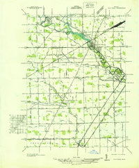
1936 Map of Flat Rock
USGS Topo · Published 1936About this map
The Huron River winds through the heart of this 1930s landscape, serving as a primary corridor for both recreation and industry between Flat Rock and Rockwood. The area shows a transition from structured town centers to a dense network of rural drainage systems, including the Babcock Drain and Duff Drain, which supported the surrounding agricultural lands of Ash and Brownstown townships. The influence of the railroad is central to the local economy, evidenced by the expansive Flat Rock Yard and the paths of the Detroit and Ironton RR.
Find a feature on this map
120 named features on this map. Tap any name to fly to it.
Don’t see what you’re looking for? This feature index may not catch every label — zoom into the map to look around manually.
Map Details
Editions of this 1936 Flat Rock Map
This is the sole edition of this map. No revisions or reprints were ever made.
Other maps of this area

1906 · Wyandotte
USGS Topo · 1:62,500

1906 · Romulus
USGS Topo · 1:62,500

1912 · Wyandotte
USGS Topo · 1:62,500

1912 · Monroe
USGS Topo · 1:62,500

1914 · Monroe
USGS Topo · 1:62,500

1927 · Monroe
USGS Topo · 1:31,680

1928 · Romulus
USGS Topo · 1:62,500

1929 · Wyandotte
USGS Topo · 1:62,500

1936 · Wyandotte
USGS Topo · 1:31,680
1936 · Belleville
USGS Topo · 1:31,680
Featured Places
- Brownstown Charter Township, MI
- Frenchtown Charter Township, MI
- Huron Charter Township, MI
- Woodhaven, MI
- Berlin Charter Township, MI