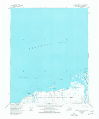
1955 Map of Flaxman Island A-1
USGS Topo · Published 1977About this map
The Arctic National Wildlife Range dominates this coastal landscape, where the frozen waters of the Beaufort Sea meet the North Slope. Aerial photography from the mid-1950s captures a sparse, wind-swept territory where the Sadlerochit River and Katakturok Creek drain into Camden Bay. Human presence is minimal, marked only by an isolated cabin, a small site labeled Barbara, and a Tractor Trail that skirts the coastline near Anderson Point. To the east, the braided deltas of the Okpilak River and Hulahula River converge behind the shelter of Arey Island. This survey reveals the critical hydrographic features of the era, including detailed sand shoals and soundings that define the shallow transition from the tundra to the sea.
Find a feature on this map
16 named features on this map. Tap any name to fly to it.
Don’t see what you’re looking for? This feature index may not catch every label — zoom into the map to look around manually.
Map Details
Editions of this 1955 Flaxman Island A-1 Map
3 editions found
Other maps of this area

1951 · Barter Island
USGS Topo · 1:250,000

1951 · Demarcation Point
USGS Topo · 1:250,000

1951 · Mt. Michelson
USGS Topo · 1:250,000

1955 · Flaxman Island
USGS Topo · 1:250,000

1955 · Demarcation Point
USGS Topo · 1:250,000

1955 · Flaxman Island A-1
USGS Topo · 1:63,360

1955 · Mount Michelson D-2
USGS Topo · 1:63,360

1955 · Barter Island A-5
USGS Topo · 1:63,360

1955 · Mount Michelson D-1
USGS Topo · 1:63,360

1955 · Demarcation Point D-5
USGS Topo · 1:63,360