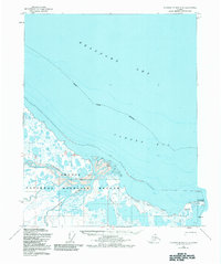
1955 Map of Flaxman Island A-3
USGS Topo · Published 1984About this map
The Arctic National Wildlife Refuge dominates this coastal landscape where the Canning River and Tamayariak River delta into the Beaufort Sea. Photogrammetric data from the mid-1950s reveals a complex network of coastal lagoons and mud flats along Camden Bay. While the interior remains largely a wilderness of unnamed lakes and wetlands, human presence is marked by isolated landmarks such as Canning and Walker, alongside simple Cabins near Konganevik Point. This area reflects a period of early surveying within the North Slope Borough, where access was primarily limited to seasonal Tractor Trails. The map captures the delicate transition between the tundra and the sea before modern industrial footprints expanded across the North Slope.
Find a feature on this map
14 named features on this map. Tap any name to fly to it.
Don’t see what you’re looking for? This feature index may not catch every label — zoom into the map to look around manually.
Map Details
Editions of this 1955 Flaxman Island A-3 Map
2 editions found
Other maps of this area

1951 · Mt. Michelson
USGS Topo · 1:250,000

1955 · Flaxman Island
USGS Topo · 1:250,000

1955 · Mount Michelson D-3
USGS Topo · 1:63,360

1955 · Mount Michelson D-4
USGS Topo · 1:63,360

1955 · Flaxman Island A-4
USGS Topo · 1:63,360

1955 · Mount Michelson D-2
USGS Topo · 1:63,360

1955 · Flaxman Island A-3
USGS Topo · 1:63,360

1956 · Mt. Michelson
USGS Topo · 1:250,000
1962 · Flaxman Island A-4
USGS Topo · 1:50,000
2018 · Flaxman Island A-4 NE
USGS Topo · 1:25,000