
1955 Map of Flaxman Island A-4
USGS Topo · Published 1967About this map
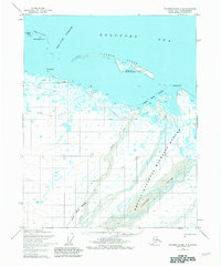
Flaxman Island stands as a prominent barrier between the shallow coastal lagoons and the open Beaufort Sea in this 1950s survey of Alaska's northern coast. The landscape is defined by the braided delta of the Canning River, which marks a significant portion of the eastern boundary of the Arctic National Wildlife Range. A network of smaller waterways like the Staines River and unnamed ponds punctuate the tundra, while a Tractor Trail follows the shoreline, indicating the early methods of traversing this remote environment. Near the coast, a single Cabin and landmarks like Pt Thomson and Brownlow Pt provide rare points of human reference. The map also delineates the offshore Maguire Islands, including North Star Island and Duchess Island, which protect the Mary Sachs Entrance. This topographic study reveals the intricate, shifting nature of the arctic coastline before modern industrial development arrived.
Find a feature on this map
14 named features on this map. Tap any name to fly to it.
Don’t see what you’re looking for? This feature index may not catch every label — zoom into the map to look around manually.
Map Details
Editions of this 1955 Flaxman Island A-4 Map
2 editions found
Other maps of this area

1951 · Mt. Michelson
USGS Topo · 1:250,000

1955 · Flaxman Island
USGS Topo · 1:250,000

1955 · Mount Michelson D-5
USGS Topo · 1:63,360

1955 · Mount Michelson D-3
USGS Topo · 1:63,360

1955 · Mount Michelson D-4
USGS Topo · 1:63,360

1955 · Flaxman Island A-5
USGS Topo · 1:63,360

1955 · Flaxman Island A-3
USGS Topo · 1:63,360
1955 · Flaxman Island B-5
USGS Topo · 1:63,360

1956 · Mt. Michelson
USGS Topo · 1:250,000
1962 · Flaxman Island A-4
USGS Topo · 1:50,000