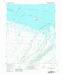
1955 Map of Flaxman Island A-4
USGS Topo · Published 1981About this map
Flaxman Island stands as a narrow barrier between the Beaufort Sea and the mainland coast of Alaska’s North Slope. This mid-century survey documents the area as petroleum exploration and conservation efforts began to overlap in the high Arctic. The Arctic National Wildlife Refuge boundary bisects the map, protecting the delta of the Canning River and its braided channels. Historical human activity is concentrated at Leffingwell Camp National Historical Site, which includes a cabin on the island’s southern shore. The transition from early exploration to industrial surveying is visible through scattered drill holes and a Tractor Trail that cuts across the permafrost landscape. The coastal geography is defined by shallow lagoons and points like Pt Thomson and Brownlow Pt, providing a baseline for the region before the impacts of modern infrastructure.
Find a feature on this map
17 named features on this map. Tap any name to fly to it.
Don’t see what you’re looking for? This feature index may not catch every label — zoom into the map to look around manually.
Map Details
Editions of this 1955 Flaxman Island A-4 Map
2 editions found
Other maps of this area

1951 · Mt. Michelson
USGS Topo · 1:250,000

1955 · Flaxman Island
USGS Topo · 1:250,000

1955 · Mount Michelson D-5
USGS Topo · 1:63,360

1955 · Mount Michelson D-3
USGS Topo · 1:63,360

1955 · Mount Michelson D-4
USGS Topo · 1:63,360

1955 · Flaxman Island A-5
USGS Topo · 1:63,360

1955 · Flaxman Island A-4
USGS Topo · 1:63,360

1955 · Flaxman Island A-3
USGS Topo · 1:63,360
1955 · Flaxman Island B-5
USGS Topo · 1:63,360

1956 · Mt. Michelson
USGS Topo · 1:250,000