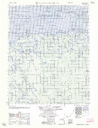
1962 Map of Flaxman Island A-5
USGS Topo · Published 1962About this map
The Maguire Islands form a protective barrier against the Beaufort Sea along this stretch of the Alaskan coast, shielding the shallow waters of Mikkelsen Bay. This 1962 edition, compiled from 1950s aerial photography and hydrographic charts, documents a transitional era of Arctic infrastructure. Coastal landmarks like Bullen Point and Point Sweeney are noted for their modest developments, including a small boat anchorage and a landing strip at Bullen Point. Inland, the landscape is defined by an intricate network of thaw lakes and tundra, traversed by a solitary Tractor Trail that skirts the coastline. The map records several named coastal landforms such as Point Gordon and Point Hopson, alongside the distinct barrier landmasses of Alaska Island, Challenge Island, and Duchess Island, separated by the Challenge Entrance.
Find a feature on this map
13 named features on this map. Tap any name to fly to it.
Don’t see what you’re looking for? This feature index may not catch every label — zoom into the map to look around manually.
Map Details
Editions of this 1962 Flaxman Island A-5 Map
This is the sole edition of this map. No revisions or reprints were ever made.
Other maps of this area

1951 · Beechey Point
USGS Topo · 1:250,000

1951 · Sagavanirktok D-5
USGS Topo · 1:250,000

1951 · Mt. Michelson
USGS Topo · 1:250,000

1955 · Flaxman Island
USGS Topo · 1:250,000

1955 · Beechey Point
USGS Topo · 1:250,000

1955 · Mount Michelson D-5
USGS Topo · 1:63,360

1955 · Mount Michelson D-4
USGS Topo · 1:63,360

1955 · Beechey Point B-1
USGS Topo · 1:63,360

1955 · Flaxman Island A-5
USGS Topo · 1:63,360

1955 · Beechey Point A-1
USGS Topo · 1:63,360