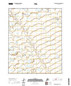
2018 Map of Flaxman Island A-5 SW
USGS Topo · Published 2018About this map
Tundra and wetlands dominate this 2018 survey of the Alaskan Arctic, where the landscape is defined by an intricate network of small lakes and ponds across the North Slope. The area is divided by the Public Land Survey System grids of T9n R20e, T9n R21e, T8n R21e, and T8n R22e. This map illustrates the hydrology typical of the region, featuring hundreds of unnamed water bodies and saturated wetlands as documented by the National Wetlands Inventory between 1978 and 1982. The absence of named settlements or roads reflects the extremely remote character of this terrain, located north of the Brooks Range along the northern coastal plain.
Find a feature on this map
4 named features on this map. Tap any name to fly to it.
Don’t see what you’re looking for? This feature index may not catch every label — zoom into the map to look around manually.
Map Details
Editions of this 2018 Flaxman Island A-5 SW Map
This is the sole edition of this map. No revisions or reprints were ever made.
Other maps of this area

1951 · Beechey Point
USGS Topo · 1:250,000

1951 · Sagavanirktok D-5
USGS Topo · 1:250,000

1951 · Mt. Michelson
USGS Topo · 1:250,000

1955 · Flaxman Island
USGS Topo · 1:250,000

1955 · Beechey Point
USGS Topo · 1:250,000

1955 · Mount Michelson D-5
USGS Topo · 1:63,360

1955 · Flaxman Island A-5
USGS Topo · 1:63,360

1955 · Beechey Point A-1
USGS Topo · 1:63,360
1955 · Sagavanirktok D-1
USGS Topo · 1:63,360

1956 · Mt. Michelson
USGS Topo · 1:250,000