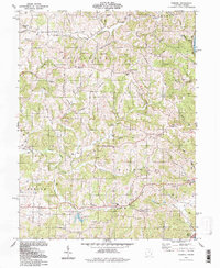
1994 Map of Fleming
USGS Topo · Published 1998About this map
Churchtown and Fleming anchor this 1990s overview of Washington County, where the landscape is defined by the winding drainages of Rainbow Creek and the South Branch Wolf Creek. The map reveals a deeply rooted rural infrastructure, punctuated by numerous country churches and cemeteries such as Bethel Ch and the McAvan Cem. A legacy of transportation and industry is evident in the Old Railroad Grade and a Covered Bridge crossing Horse Run, while the southeastern corner touches the Muskingum River at Moore Junction. Extensive development of a Gas and Oil Field is documented throughout the townships, with hundreds of active and former well sites scattered across the ridges. Education history is marked by the Township Jr High Sch and St Johns Sch, serving communities like Locust Fork and Pinehurst.
Find a feature on this map
62 named features on this map. Tap any name to fly to it.
Don’t see what you’re looking for? This feature index may not catch every label — zoom into the map to look around manually.
Map Details
Editions of this 1994 Fleming Map
This is the sole edition of this map. No revisions or reprints were ever made.
Other maps of this area

1902 · Parkersburg
USGS Topo · 1:62,500

1903 · Macksburg
USGS Topo · 1:62,500

1904 · Parkersburg
USGS Topo · 1:62,500

1904 · Marietta
USGS Topo · 1:62,500

1905 · Macksburg
USGS Topo · 1:62,500

1909 · Caldwell
USGS Topo · 1:62,500

1912 · Caldwell
USGS Topo · 1:62,500

1924 · Marietta
USGS Topo · 1:62,500

1927 · Marietta
USGS Topo · 1:62,500

1949 · Clarksburg
USGS Topo · 1:250,000