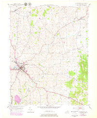
1951 Map of Flemingsburg
USGS Topo · Published 1979About this map
Flemingsburg serves as the focal point of this mid-century portrait of Fleming County, where the town's street grid is flanked by the Reservoir and the County Cemetery. The landscape is defined by the winding course of Fleming Creek and its many tributaries, including Town Branch and Wilson Run. This survey captures a mix of traditional agriculture and emerging modern infrastructure, such as the Drive-In Theater located southeast of the main town. Smaller rural centers like Mount Carmel, Beechburg, and Bluebank are documented alongside local landmarks like Fitche Chapel Cem and Arnold Cem. The map provides a clear look at local industry through features like the Rock Quarry (Inactive), while the 1970s revisions, shown in purple, highlight the expansion of roads and buildings that occurred in the decades following the initial 1951 field check.
Find a feature on this map
32 named features on this map. Tap any name to fly to it.
Don’t see what you’re looking for? This feature index may not catch every label — zoom into the map to look around manually.
Map Details
Editions of this 1951 Flemingsburg Map
3 editions found
Other maps of this area

1915 · Maysville
USGS Topo · 1:62,500

1919 · Maysville
USGS Topo · 1:62,500

1929 · Springdale
USGS Topo · 1:48,000

1935 · Springdale
USGS Topo · 1:62,500

1951 · Hillsboro
USGS Topo · 1:24,000

1951 · Plummers Landing
USGS Topo · 1:24,000

1951 · Burtonville
USGS Topo · 1:24,000

1951 · Flemingsburg
USGS Topo · 1:24,000

1952 · Sherburne
USGS Topo · 1:24,000

1952 · Elizaville
USGS Topo · 1:24,000