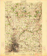
1922 Map of Flint
USGS Topo · Published 1922About this map
The city of Flint and its industrial street grid dominate the southern portion of this 1920s-era survey, revealing the infrastructure of an emerging manufacturing hub. The Flint River snakes through the landscape, flanked by the Michigan Electric and the Grand Trunk rail lines, which facilitated the movement of goods and laborers. Beyond the dense city blocks, the terrain gives way to a network of rural townships like Thetford and Davison, where the settlement pattern is defined by an extraordinary number of one-room schoolhouses such as Wildcat School, Bunnell School, and Goodenough School. This layout underscores the agrarian character that persisted just outside the city limits, even as the Waterworks and major cemeteries like Gracelawn Cemetery signaled the growth of a modern municipality. The map captures a moment of transition where old farm roads meet industrial rail corridors, connecting smaller outposts like Clio and Otisville to the urban core.
Find a feature on this map
76 named features on this map. Tap any name to fly to it.
Don’t see what you’re looking for? This feature index may not catch every label — zoom into the map to look around manually.
Map Details
Editions of this 1922 Flint Map
3 editions found
Other maps of this area

1919 · Saginaw
USGS Topo · 1:62,500

1919 · Burt
USGS Topo · 1:62,500

1920 · Flint
USGS Topo · 1:62,500

1920 · Holly
USGS Topo · 1:62,500

1921 · Burt
USGS Topo · 1:62,500

1922 · Holly
USGS Topo · 1:62,500

1922 · Durand
USGS Topo · 1:62,500

1922 · Flint
USGS Topo · 1:62,500

1941 · Saginaw
USGS Topo · 1:62,500

1943 · Holly
USGS Topo · 1:62,500