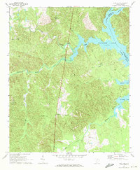
1971 Map of Flint Hill
USGS Topo · Published 1972About this map
Wateree Lake dominates the eastern boundary of this Fairfield County landscape, where the Catawba River and Wateree River converge amidst a complex system of wooded tributaries. This 1971 field check records the rural character of the region just before significant modern development, centered on small settlements like Flint Hill and Bucklick. The map reveals a community defined by its spiritual and logistical hubs, including Mt Zion Ch, Rock Hill Ch, and White Oak Ch. Significant waterways like Big Wateree Creek and Dutchmans Creek carve through the terrain, while the presence of a Landing Strip and a Gravel Pit indicates the local infrastructure and industry of the early 1970s. The tri-county boundary where Fairfield, Lancaster, and Kershaw meet in the riverbed provides a specific point of interest for researchers tracing historical jurisdictional lines.
Find a feature on this map
20 named features on this map. Tap any name to fly to it.
Don’t see what you’re looking for? This feature index may not catch every label — zoom into the map to look around manually.
Map Details
Editions of this 1971 Flint Hill Map
2 editions found
Other maps of this area

1904 · Columbia
USGS Topo · 1:125,000

1941 · Spartanburg
USGS Topo · 1:250,000

1942 · Camden
USGS Topo · 1:125,000

1953 · Spartanburg
USGS Topo · 1:250,000

1960 · Spartanburg
USGS Topo · 1:250,000

1963 · Spartanburg
USGS Topo · 1:250,000

1964 · Spartanburg
USGS Topo · 1:250,000

1968 · Lancaster SE
USGS Topo · 1:24,000
1969 · Great Falls
USGS Topo · 1:24,000
1969 · Winnsboro
USGS Topo · 1:24,000