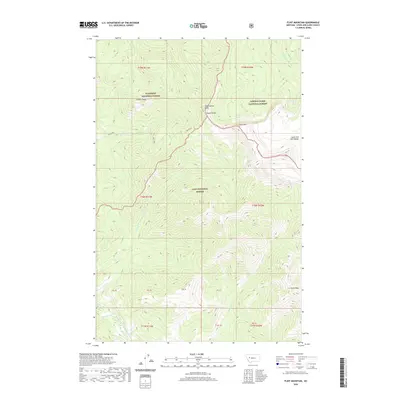
2020 Map of Flint Mountain
USGS Topo · Published 2020About this map
Flint Mtn and the Trident Peaks define this high-altitude landscape where three major national forests meet. This 2020 survey documents a complex hydrological divide within the Lewis and Clark Range, where headwaters for different drainage systems originate. Water flows from high points like Triple Divide and Observation Point into diverse basins, including the S Fork Sun River to the northeast and the Dry Fork N Fork Blackfoot River to the southwest. The map captures the administrative intersection of the Flathead National Forest, Lewis & Clark National Forest, and Lolo National Forest. This remote backcountry area is characterized by high peaks such as Evans Peak and small alpine water bodies like Sun Lake, offering a detailed view of the Montana wilderness before significant human settlement or infrastructure development.
Find a feature on this map
28 named features on this map. Tap any name to fly to it.
Don’t see what you’re looking for? This feature index may not catch every label — zoom into the map to look around manually.
Map Details
Editions of this 2020 Flint Mountain Map
This is the sole edition of this map. No revisions or reprints were ever made.
Other maps of this area

1902 · Ovando
USGS Topo · 1:125,000

1903 · Coopers Lake
USGS Topo · 1:125,000

1905 · Ovando
USGS Topo · 1:125,000

1955 · Choteau
USGS Topo · 1:250,000

1957 · Choteau
USGS Topo · 1:250,000

1958 · Choteau
USGS Topo · 1:250,000

1962 · Choteau
USGS Topo · 1:250,000

1968 · Spread Mountain
USGS Topo · 1:24,000

1968 · Olson Peak
USGS Topo · 1:24,000
1968 · Lake Mountain
USGS Topo · 1:24,000