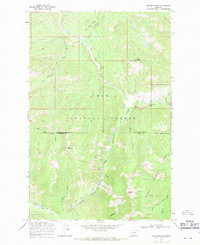
1968 Map of Lake Mountain
USGS Topo · Published 1971About this map
The Lolo National Forest, Lewis and Clark National Forest, and Helena National Forest converge at this remote interior boundary between Lewis and Clark and Powell Counties. The landscape is dominated by the upper reaches of the Blackfoot River and its major tributaries, including the Dry Fork and North Fork. Resource management and high-country navigation are the primary activities visible, evidenced by the North Fork Guard Sta and a high Lookout Tower positioned at Point 7487. A network of pack trails, such as the Dobrota Trail and McDermott Trail, provides the only infrastructure through this steep terrain. Small-scale mining activity is indicated by several Prospects and a Prospect located near Mineral Hill and Mineral Creek, suggesting the area's history of mineral exploration.
Find a feature on this map
33 named features on this map. Tap any name to fly to it.
Don’t see what you’re looking for? This feature index may not catch every label — zoom into the map to look around manually.
Map Details
Editions of this 1968 Lake Mountain Map
2 editions found
Other maps of this area

1902 · Ovando
USGS Topo · 1:125,000

1903 · Coopers Lake
USGS Topo · 1:125,000

1905 · Ovando
USGS Topo · 1:125,000

1955 · Choteau
USGS Topo · 1:250,000

1957 · Choteau
USGS Topo · 1:250,000

1958 · Choteau
USGS Topo · 1:250,000

1962 · Choteau
USGS Topo · 1:250,000

1968 · Spread Mountain
USGS Topo · 1:24,000

1968 · Olson Peak
USGS Topo · 1:24,000
1968 · Coopers Lake
USGS Topo · 1:24,000