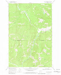
1968 Map of Lake Mountain
USGS Topo · Published 1981About this map
The boundary between Lolo National Forest and Helena National Forest meets the county line of Lewis and Clark and Powell Counties in this remote mountain landscape. This 1968 field-checked survey reveals an area defined by primitive access, where travel relied on a network of pack trails rather than roads. The North Fork (Pack) Trail and Cabin Creek (Pack) Trail trace the drainages of the North Fork Blackfoot River and Cabin Creek, providing passage through steep terrain near Lake Mountain. The presence of the North Fork Guard Sta and the Lookout Falls Tower Point highlights the essential infrastructure of early forest management and fire observation in the Montana wilderness. These features, along with names like Mineral Hill and Windy Pass, offer a clear picture of the land's utility for forestry and seasonal navigation before modern development.
Find a feature on this map
26 named features on this map. Tap any name to fly to it.
Don’t see what you’re looking for? This feature index may not catch every label — zoom into the map to look around manually.
Map Details
Editions of this 1968 Lake Mountain Map
2 editions found
Other maps of this area

1902 · Ovando
USGS Topo · 1:125,000

1903 · Coopers Lake
USGS Topo · 1:125,000

1905 · Ovando
USGS Topo · 1:125,000

1955 · Choteau
USGS Topo · 1:250,000

1957 · Choteau
USGS Topo · 1:250,000

1958 · Choteau
USGS Topo · 1:250,000

1962 · Choteau
USGS Topo · 1:250,000

1968 · Spread Mountain
USGS Topo · 1:24,000

1968 · Olson Peak
USGS Topo · 1:24,000
1968 · Coopers Lake
USGS Topo · 1:24,000