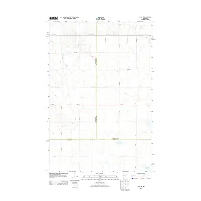
2013 Map of Flom NE
USGS Topo · Published 2013About this map
The tri-county boundary of Norman, Mahnomen, and Becker counties meets in this rural landscape, defined by a transition from the prairie lands to the lake-studded terrain typical of western Minnesota. Small bodies of water like Apple Lake and Clarence Lake anchor the southern portion of the quadrangle, while Spring Cr flows through the northeast corner. The land is partitioned by a strictly rectangular grid of township roads and agricultural avenues, such as 150th Ave and 450th St, which reflect the region's deep roots in the Public Land Survey System. Modern transit is provided by Mn-113, which cuts east-west across the center of the sheet, and a series of county highways including Co Hwy-6 and Co Hwy-10 that facilitate movement between these remote farming communities.
Find a feature on this map
29 named features on this map. Tap any name to fly to it.
Don’t see what you’re looking for? This feature index may not catch every label — zoom into the map to look around manually.
Map Details
Editions of this 2013 Flom NE Map
This is the sole edition of this map. No revisions or reprints were ever made.
Other maps of this area

1918 · Flom
USGS Topo · 1:62,500

1952 · Grand Forks
USGS Topo · 1:250,000

1954 · Bemidji
USGS Topo · 1:250,000

1956 · Grand Forks
USGS Topo · 1:250,000

1957 · Bemidji
USGS Topo · 1:250,000

1958 · Bemidji
USGS Topo · 1:250,000

1965 · Waukon
USGS Topo · 1:24,000

1966 · Flom
USGS Topo · 1:24,000

1966 · Grand Forks
USGS Topo · 1:250,000
1966 · Tilde Lake
USGS Topo · 1:24,000