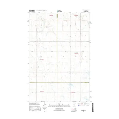
2016 Map of Flom NE
USGS Topo · Published 2016About this map
The tri-county boundary of Norman, Mahnomen, and Becker counties defines this western Minnesota landscape. The terrain is characterized by a dense network of glacial potholes and small wetlands, with Apple Lake and Clarence Lake serving as prominent water bodies in the southern sections. A rigid grid of section-line roads, including 450th St, 460th St, and 150th Ave, illustrates the persistence of the Public Land Survey System in organizing the agricultural territory. While the area is largely devoid of concentrated settlements, the intricate layout of rural routes like Co St Aid Hwy 6 and Co St Aid Hwy 10 provides a detailed look at the connectivity between remote farmsteads and the larger county road system in the mid-2010s. The presence of Spring Cr in the northeast corner further highlights the subtle drainage patterns of this prairie-pothole region.
Find a feature on this map
38 named features on this map. Tap any name to fly to it.
Don’t see what you’re looking for? This feature index may not catch every label — zoom into the map to look around manually.
Map Details
Editions of this 2016 Flom NE Map
This is the sole edition of this map. No revisions or reprints were ever made.
Other maps of this area

1918 · Flom
USGS Topo · 1:62,500

1952 · Grand Forks
USGS Topo · 1:250,000

1954 · Bemidji
USGS Topo · 1:250,000

1956 · Grand Forks
USGS Topo · 1:250,000

1957 · Bemidji
USGS Topo · 1:250,000

1958 · Bemidji
USGS Topo · 1:250,000

1965 · Waukon
USGS Topo · 1:24,000

1966 · Flom
USGS Topo · 1:24,000

1966 · Grand Forks
USGS Topo · 1:250,000
1966 · Tilde Lake
USGS Topo · 1:24,000