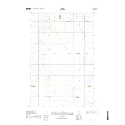
2019 Map of Flom NE
USGS Topo · Published 2019About this map
Apple Lake and Clarence Lake sit at the southern edge of this agricultural landscape, where the borders of Becker, Norman, and Mahnomen counties converge. The terrain is defined by a rigorous section-line grid of rural roads, including 460th St and 150th Ave, which connect isolated farmsteads across the prairie. Small prairie potholes and wetlands are scattered throughout the northern sections, particularly near the headwaters of Spring Cr. This 2019 survey documents the modern layout of these three counties, showing the enduring reliance on the township and range system. Significant transit corridors such as Co St Aid Hwy 6 and Co St Aid Hwy 10 provide the primary east-west movement through this quiet corner of Northwest Minnesota, where the drainage patterns of the Red River Valley begin to take shape.
Find a feature on this map
36 named features on this map. Tap any name to fly to it.
Don’t see what you’re looking for? This feature index may not catch every label — zoom into the map to look around manually.
Map Details
Editions of this 2019 Flom NE Map
This is the sole edition of this map. No revisions or reprints were ever made.
Other maps of this area

1918 · Flom
USGS Topo · 1:62,500

1952 · Grand Forks
USGS Topo · 1:250,000

1954 · Bemidji
USGS Topo · 1:250,000

1956 · Grand Forks
USGS Topo · 1:250,000

1957 · Bemidji
USGS Topo · 1:250,000

1958 · Bemidji
USGS Topo · 1:250,000

1965 · Waukon
USGS Topo · 1:24,000

1966 · Flom
USGS Topo · 1:24,000

1966 · Grand Forks
USGS Topo · 1:250,000
1966 · Tilde Lake
USGS Topo · 1:24,000