
1967 Map of Flomot
USGS Topo · Published 1969About this map
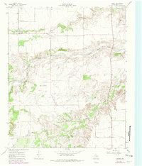
Flomot serves as the central hub of this West Texas landscape, situated at the edge of the Caprock where the plains break into the canyonlands of the North Pease River. The 1967 field-checked data illustrates a remote agricultural and ranching district defined by seasonal watercourses like Alamosa Creek and Tom Ball Creek. A distinct transition in topography is visible as the flat upland plains, marked by scattered Gravel Pits, give way to the intricate drainage systems carved by the river and its tributaries. Local history is anchored at the Memorial Park (Cem) just north of the town site, while the presence of Miller Springs and Quitaque Creek suggests the vital role of water sources in this arid environment. The map captures the region before extensive modern development, showing the original footprint of rural roads and scattered windmills across the Motley County terrain.
Find a feature on this map
9 named features on this map. Tap any name to fly to it.
Don’t see what you’re looking for? This feature index may not catch every label — zoom into the map to look around manually.
Map Details
Editions of this 1967 Flomot Map
2 editions found
Other maps of this area

1954 · Plainview
USGS Topo · 1:250,000

1958 · Plainview
USGS Topo · 1:250,000

1966 · Matador
USGS Topo · 1:24,000

1967 · Quitaque
USGS Topo · 1:24,000

1967 · North Windmill
USGS Topo · 1:24,000

1967 · Quitaque Peaks
USGS Topo · 1:24,000

1967 · Dick Moore Canyon
USGS Topo · 1:24,000

1967 · Hornica Creek
USGS Topo · 1:24,000

1967 · Whiteflat
USGS Topo · 1:24,000
1967 · Folley
USGS Topo · 1:24,000