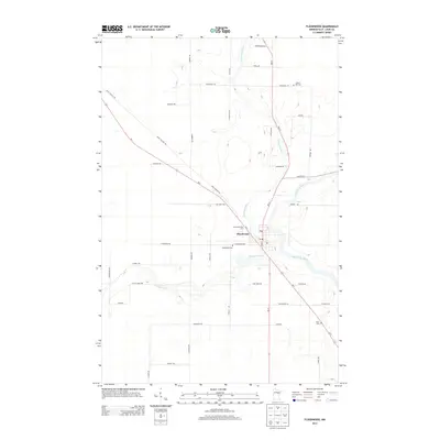
2013 Map of Floodwood
USGS Topo · Published 2013About this map
Floodwood sits at a major hydrologic confluence where the Floodwood River and E Savanna River join the larger Saint Louis River. This 2013 survey illustrates the town's position at the intersection of Us-2 and MN-73, showing a landscape defined by water and a grid of rural roads named for local families. Genealogists will find several burial sites including Floodwood Cem just south of the town center, Forest Hill Cem to the north, and Hope Cem near the southeastern edge of the map. The road network, featuring names like Saint Vincent Rd and Parantala Rd, suggests a community rooted in its early settlement patterns and geographic layout. Beyond the central hub of Floodwood, the map details the winding course of the rivers as they cut through the surrounding Saint Louis County terrain.
Find a feature on this map
40 named features on this map. Tap any name to fly to it.
Don’t see what you’re looking for? This feature index may not catch every label — zoom into the map to look around manually.
Map Details
Editions of this 2013 Floodwood Map
This is the sole edition of this map. No revisions or reprints were ever made.
Other maps of this area

1953 · Duluth
USGS Topo · 1:250,000

1954 · Hibbing
USGS Topo · 1:250,000

1957 · Hibbing
USGS Topo · 1:250,000

1958 · Hibbing
USGS Topo · 1:250,000

1958 · Duluth
USGS Topo · 1:250,000

1963 · Gowan
USGS Topo · 1:24,000

1963 · Prairie Lake
USGS Topo · 1:24,000

1963 · Elmer
USGS Topo · 1:24,000

1963 · Toivola SW
USGS Topo · 1:24,000
1963 · Mc Carty River
USGS Topo · 1:24,000