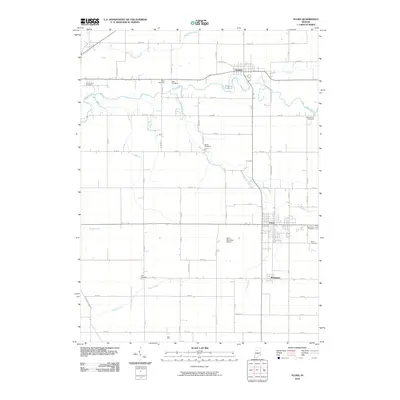
2010 Map of Flora
USGS Topo · Published 2010About this map
Flora and Camden anchor this Carroll County landscape, where the agricultural grid is defined by a dense network of country roads and drainage ditches. The area’s genealogical record is remarkably well-preserved through numerous family and community burial grounds, including Sharp Point Cemetery, Wise Cemetery, and Nettle Cemetery, which sit among the undulating paths of Deer Creek and Bachelor Run. This 2010 survey illustrates the persistence of small-town settlement patterns in North Central Indiana, showing the spatial relationship between the village of Bringhurst and the larger hub of Flora. Industrial and transportation infrastructure is represented by the Flora Municipal Airport and a series of meticulously managed waterways like Sines Ditch and Ayres Ditch, which support the surrounding farmland. The map provides a clear view of the rural township structure just before the modern era of significant digital revision.
Find a feature on this map
67 named features on this map. Tap any name to fly to it.
Don’t see what you’re looking for? This feature index may not catch every label — zoom into the map to look around manually.
Map Details
Editions of this 2010 Flora Map
This is the sole edition of this map. No revisions or reprints were ever made.
Other maps of this area

1953 · Danville
USGS Topo · 1:250,000

1955 · Danville
USGS Topo · 1:250,000

1956 · Danville
USGS Topo · 1:250,000

1961 · Pyrmont
USGS Topo · 1:24,000

1961 · Rossville
USGS Topo · 1:24,000

1961 · Burlington
USGS Topo · 1:24,000

1962 · Deer Creek
USGS Topo · 1:24,000

1962 · Flora
USGS Topo · 1:24,000

1962 · Burrows
USGS Topo · 1:24,000

1962 · Delphi
USGS Topo · 1:24,000