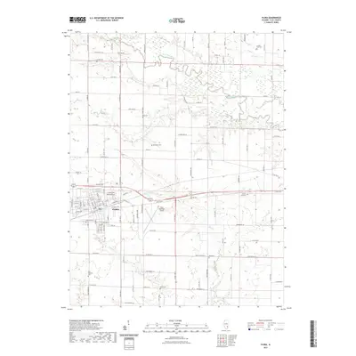
2021 Map of Flora
USGS Topo · Published 2021About this map
The city of Flora anchors this modern survey of Clay County, showing the intersection of local industry and the rural Illinois landscape. The Little Wabash River meanders across the northern reaches, joined by tributaries such as Grove Creek and Buck Creek, creating a complex drainage pattern that has shaped settlement here for generations. The township's history is well-preserved in its numerous small burial grounds, including the Jenkins Cemetery in the north and the Bloom Cemetery to the south. Central to the local economy and transportation is the Flora Municipal Airport, situated just east of the main city center. Genealogists will find a wealth of specific landmarks, from the Saint Stephens Cemetery in the southwest to the uniquely named Number Four Cemetery in the northeast, providing a clear geographic context for family records and local history.
Find a feature on this map
107 named features on this map. Tap any name to fly to it.
Don’t see what you’re looking for? This feature index may not catch every label — zoom into the map to look around manually.
Map Details
Editions of this 2021 Flora Map
This is the sole edition of this map. No revisions or reprints were ever made.
Other maps of this area

1948 · Flora
USGS Topo · 1:62,500

1949 · Flora
USGS Topo · 1:62,500

1952 · Xenia
USGS Topo · 1:62,500

1953 · Sailor Springs
USGS Topo · 1:62,500

1956 · Edgewood
USGS Topo · 1:62,500

1958 · Belleville
USGS Topo · 1:250,000

1962 · Belleville
USGS Topo · 1:250,000
1968 · Xenia NE
USGS Topo · 1:24,000
1968 · Johnsonville
USGS Topo · 1:24,000

1970 · Clay City
USGS Topo · 1:24,000