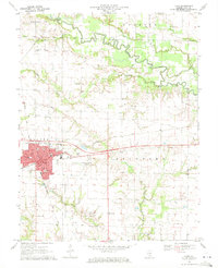
1970 Map of Flora
USGS Topo · Published 1971About this map
The Baltimore and Ohio railroad corridor anchors this mid-century look at Clay County, crossing through the heart of Flora. This industrial and transit hub is detailed down to its local institutions, including Seminary School, the Junior High School, and the Flora Municipal Airport. To the north, the southern portion of Louisville appears along the Little Wabash River, where the landscape transitions into a network of small creeks and rural landmarks.
Find a feature on this map
37 named features on this map. Tap any name to fly to it.
Don’t see what you’re looking for? This feature index may not catch every label — zoom into the map to look around manually.
Map Details
Editions of this 1970 Flora Map
This is the sole edition of this map. No revisions or reprints were ever made.
Other maps of this area

1948 · Flora
USGS Topo · 1:62,500

1949 · Flora
USGS Topo · 1:62,500

1952 · Xenia
USGS Topo · 1:62,500

1953 · Sailor Springs
USGS Topo · 1:62,500

1956 · Edgewood
USGS Topo · 1:62,500

1958 · Belleville
USGS Topo · 1:250,000

1962 · Belleville
USGS Topo · 1:250,000
1968 · Xenia NE
USGS Topo · 1:24,000
1968 · Johnsonville
USGS Topo · 1:24,000

1970 · Clay City
USGS Topo · 1:24,000