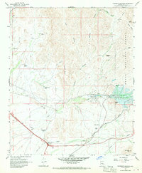
1966 Map of Florence Junction
USGS Topo · Published 1970About this map
Florence Junction serves as the focal point for this mid-1960s desert landscape, situated at the intersection of major desert thoroughfares. The terrain is defined by a series of rugged canyons including Tule Canyon, Whitlow Canyon, and Peacock Canyon, which drain the eastern portions of the Tonto National Forest. Land use in this era shows a transition from traditional livestock operations at Burns Ranch and Milk Ranch to newer recreational and infrastructural developments like the Queen Valley Golf Course and the Whitlow Ranch Flood Control Basin. The presence of the Magma Road and a Landing Strip near the junction underscores the importance of transportation and mineral transit in Pinal County. Notable high points like Elephant Butte and Dromedary Peak anchor the horizon, while numerous water catchments such as Dons Tank and Apache Land Tank reveal the critical management of water resources in this arid environment.
Find a feature on this map
36 named features on this map. Tap any name to fly to it.
Don’t see what you’re looking for? This feature index may not catch every label — zoom into the map to look around manually.
Map Details
Editions of this 1966 Florence Junction Map
3 editions found
Other maps of this area

1900 · Florence
USGS Topo · 1:125,000

1902 · Florence
USGS Topo · 1:125,000

1948 · Superior
USGS Topo · 1:62,500

1948 · Iron Mountain
USGS Topo · 1:24,000

1948 · Picketpost Mtn
USGS Topo · 1:24,000

1949 · Iron Mountain
USGS Topo · 1:24,000

1949 · Picketpost Mtn
USGS Topo · 1:24,000

1954 · Mesa
USGS Topo · 1:250,000

1956 · Goldfield
USGS Topo · 1:24,000

1956 · Magma
USGS Topo · 1:24,000