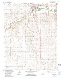
1989 Map of Florence
USGS Topo · Published 1990About this map
The Cottonwood River and its meandering tributary Doyle Creek define the landscape around Florence, where the terrain transitions from river bottomland to the undulating prairie of the Fairplay and Milton districts. This 1989 revision highlights a region where the economy is deeply rooted in both agriculture and petroleum, evidenced by the extensive Doyle Oil Field and Summit Oil Field spanning the southern and western reaches. Local history is anchored by rural landmarks such as Summit Ch and the Mt Calvary Cem, while the industrial past of the area is noted by an Old Railroad Grade and several active gravel pits and quarries. The town itself is shown in detail, including Grandview Park and Moses Shane Mem Park, providing a clear look at the community infrastructure near the turn of the decade.
Find a feature on this map
27 named features on this map. Tap any name to fly to it.
Don’t see what you’re looking for? This feature index may not catch every label — zoom into the map to look around manually.
Map Details
Editions of this 1989 Florence Map
This is the sole edition of this map. No revisions or reprints were ever made.
Other maps of this area

1889 · Newton
USGS Topo · 1:125,000

1894 · Newton
USGS Topo · 1:125,000

1898 · Cottonwood Falls
USGS Topo · 1:125,000

1955 · Hutchinson
USGS Topo · 1:250,000

1957 · Florence
USGS Topo · 1:24,000

1957 · Wonsevu
USGS Topo · 1:24,000

1957 · Cedar Point
USGS Topo · 1:24,000

1957 · Lincolnville SW
USGS Topo · 1:24,000

1957 · Peabody
USGS Topo · 1:24,000

1959 · Hutchinson
USGS Topo · 1:250,000