
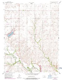
1957 Map of Lincolnville SW
USGS Topo · Published 1958About this map
The Cottonwood River snakes through the southern reaches of this landscape, its path shadowed by the Atchison Topeka and Santa Fe railroad line. This 1950s survey documents a predominantly rural Kansas territory, punctuated by the town of Florence and the smaller settlement of Oursler. Notable infrastructure of the period includes the Marion Landing Field and a local Waterworks facility. The presence of Marion County Lake in the west serves as a major geographical anchor, while several family-named burial grounds like Harter Cem and Grant Cem offer significant points of interest for genealogists tracking early Marion County residents. The network of drainage, including Martin Creek and Catlin Creek, illustrates the hydraulic patterns that shaped local agriculture and settlement long before modern irrigation changed the plains.
Find a feature on this map
17 named features on this map. Tap any name to fly to it.
Don’t see what you’re looking for? This feature index may not catch every label — zoom into the map to look around manually.
Map Details
Editions of this 1957 Lincolnville SW Map
2 editions found
Other maps of this area

1889 · Newton
USGS Topo · 1:125,000

1894 · Newton
USGS Topo · 1:125,000

1898 · Cottonwood Falls
USGS Topo · 1:125,000

1955 · Hutchinson
USGS Topo · 1:250,000

1957 · Florence
USGS Topo · 1:24,000

1957 · Wonsevu
USGS Topo · 1:24,000

1957 · Cedar Point
USGS Topo · 1:24,000

1957 · Peabody
USGS Topo · 1:24,000

1959 · Hutchinson
USGS Topo · 1:250,000

1970 · Lincolnville NE
USGS Topo · 1:24,000