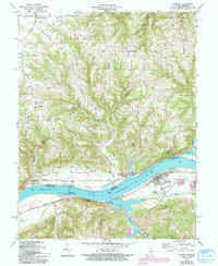
1966 Map of Florence
USGS Topo · Published 1994About this map
Markland Locks and Dam dominates the bend of the Ohio River along the border of Switzerland and Gallatin Counties, serving as a critical piece of mid-century river infrastructure. The landscape is characterized by a series of prominent ridges, including Mc Creary Ridge, Bethel Ridge, and Pleasant Ridge, which dictate the winding paths of rural thoroughfares like Pickett Road and Florence Road. Small settlements and rural community centers such as Florence, Warsaw, and East Enterprise are connected by these upland routes and riverside landings. Genealogists will find significant local history markers in the numerous small places of worship and rest, including Liberty Ch, Bethel Chapel, and the Bark Works Cem. The map illustrates a transitional period in the late 20th century where traditional agricultural river life met modern energy needs, evidenced by the proximity of the Powerplant and Substation to long-standing hamlets like Antioch and Quercus Grove.
Find a feature on this map
53 named features on this map. Tap any name to fly to it.
Don’t see what you’re looking for? This feature index may not catch every label — zoom into the map to look around manually.
Map Details
Editions of this 1966 Florence Map
4 editions found
Other maps of this area

1943 · Florence
USGS Topo · 1:24,000

1943 · Aberdeen
USGS Topo · 1:24,000

1943 · Vevay North
USGS Topo · 1:24,000

1943 · Rising Sun
USGS Topo · 1:24,000

1943 · Patriot
USGS Topo · 1:24,000

1943 · Vevay South
USGS Topo · 1:24,000

1950 · Glencoe
USGS Topo · 1:24,000

1951 · Florence
USGS Topo · 1:24,000

1951 · Rising Sun
USGS Topo · 1:24,000

1951 · Sanders
USGS Topo · 1:24,000