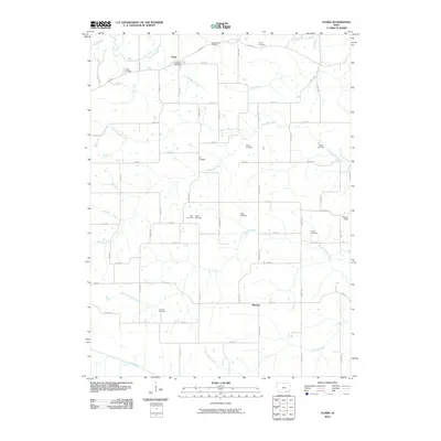
2010 Map of Floris
USGS Topo · Published 2010About this map
Floris and the surrounding Davis County countryside are defined by the intricate dendritic drainage systems of the Chequest Creek and its many branches. The settlement of Floris sits near the northern boundary, anchored by the Floris Post Office, while the hamlet of Shunem is located further south. This landscape is notably dense with small family and fraternal burial grounds, which serve as vital markers for local genealogists. These include the Odd Fellows Cemetery, Jay Cemetery, and the dual-named Stark Cemetery and Pewter Cemetery sites. The terrain is divided by a grid of rural routes such as Floris Rd and Quain Ave, which navigate the rises between the South Chequest Creek and the Fox River at the map's southern edge. This 2010 survey reflects a deeply established agricultural community where early 19th-century land divisions and family names remain visible in the placement of landmarks like Hooper Field.
Find a feature on this map
62 named features on this map. Tap any name to fly to it.
Don’t see what you’re looking for? This feature index may not catch every label — zoom into the map to look around manually.
Map Details
Editions of this 2010 Floris Map
This is the sole edition of this map. No revisions or reprints were ever made.
Other maps of this area

1954 · Centerville
USGS Topo · 1:250,000

1956 · Agency
USGS Topo · 1:24,000

1956 · Ottumwa South
USGS Topo · 1:24,000

1956 · Ottumwa South
USGS Topo · 1:62,500

1957 · Centerville
USGS Topo · 1:250,000

1958 · Centerville
USGS Topo · 1:250,000
1965 · Eldon
USGS Topo · 1:24,000

1965 · Selma
USGS Topo · 1:24,000
1970 · Milton
USGS Topo · 1:24,000
1979 · Floris
USGS Topo · 1:24,000