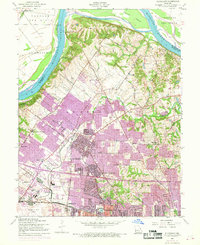
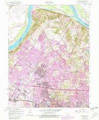
1954 Map of Florissant
USGS Topo · Published 1969About this map
The Missouri River forms the northern boundary of this landscape, separating the floodplain of Pelican Island and the Portage Des Sioux from the rapidly expanding suburbs of north St. Louis County. At mid-century, the area transitions from the riverfront bluffs near Halls Ferry to the dense residential grids of Florissant, Berkeley, and Ferguson. Significant religious and educational institutions anchor the community, including the expansive grounds of the St Stanislaus Seminary and St Josephs Convent of Mercy.
Find a feature on this map
51 named features on this map. Tap any name to fly to it.
Don’t see what you’re looking for? This feature index may not catch every label — zoom into the map to look around manually.
Map Details
Editions of this 1954 Florissant Map
5 editions found
Other maps of this area

1888 · St. Louis
USGS Topo · 1:62,500

1924 · Robertson
USGS Topo · 1:24,000

1927 · Alton
USGS Topo · 1:62,500

1927 · St. Charles
USGS Topo · 1:62,500

1933 · Creve Coeur
USGS Topo · 1:24,000

1933 · Granite City
USGS Topo · 1:24,000

1933 · Clayton
USGS Topo · 1:24,000

1933 · Saint Charles
USGS Topo · 1:62,500

1934 · Alton
USGS Topo · 1:62,500

1935 · Granite City
USGS Topo · 1:24,000