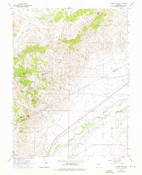
1967 Map of Flowery Peak
USGS Topo · Published 1976About this map
The Flowery Mining District dominates the eastern slopes of the Flowery Range in this mid-1960s survey, revealing a landscape defined by Nevada's historic silver and gold extraction. High-altitude mining operations such as the North Bonanza Mine, the Belmont-Uncle Sam Shaft, and the distinctive Berry Glory Hole are clearly marked along the ridges near Sevenmile Canyon. These industrial features overlook the Monte Cristo (Site) and the settlement of Sutro, which sits at the terminus of the famous Sutro Tunnel, a massive engineering feat designed to drain the Comstock Lode.
Find a feature on this map
34 named features on this map. Tap any name to fly to it.
Don’t see what you’re looking for? This feature index may not catch every label — zoom into the map to look around manually.
Map Details
Editions of this 1967 Flowery Peak Map
4 editions found
Other maps of this area

1891 · Carson
USGS Topo · 1:125,000

1891 · Wabuska
USGS Topo · 1:125,000

1893 · Carson
USGS Topo · 1:125,000

1894 · Wabuska
USGS Topo · 1:125,000

1950 · Virginia City
USGS Topo · 1:62,500

1952 · Virginia City
USGS Topo · 1:62,500

1956 · Dayton
USGS Topo · 1:62,500

1957 · Como
USGS Topo · 1:62,500

1957 · Churchill Butte
USGS Topo · 1:62,500

1957 · Reno
USGS Topo · 1:250,000