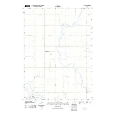
2010 Map of Floyd
USGS Topo · Published 2010About this map
Floyd sits at the southwestern edge of this landscape where the Cedar River meets the local road network, including the Floyd Post Office. The terrain is defined by a grid of agricultural section lines and a series of north-south waterways that cut through the Iowa plains. The Little Cedar River meanders through the central portion of the quadrangle, flanked by the small settlements of Howardville and Nilesville.
Find a feature on this map
31 named features on this map. Tap any name to fly to it.
Don’t see what you’re looking for? This feature index may not catch every label — zoom into the map to look around manually.
Map Details
Editions of this 2010 Floyd Map
This is the sole edition of this map. No revisions or reprints were ever made.
Other maps of this area

1954 · Mason City
USGS Topo · 1:250,000

1957 · Mason City
USGS Topo · 1:250,000

1958 · Mason City
USGS Topo · 1:250,000

1971 · Orchard
USGS Topo · 1:24,000

1971 · Charles City
USGS Topo · 1:24,000

1971 · Bassett
USGS Topo · 1:24,000

1971 · Colwell
USGS Topo · 1:24,000

1971 · Floyd
USGS Topo · 1:24,000
1971 · Roseville
USGS Topo · 1:24,000

1972 · Osage
USGS Topo · 1:24,000