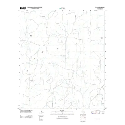
2012 Map of Fly Gap
USGS Topo · Published 2012About this map
Fly Gap anchors this section of the Texas Hill Country, situated in a landscape defined by significant elevations and seasonal watercourses. The local terrain is punctuated by prominent landmarks such as Man Mtn, Tom Green Mtn, and the distinctive Lime Peak, while Spiller Hollow and Eckert Roughs suggest the varied topography of the region. A network of rural roads, including Spillar Mine Rd and Union School Rd, hints at the area's history of mining and rural education. Genealogists will find the area's history preserved through several family and community burial grounds, specifically Fly Gap Cem, Leifeste Cem, and the Kothmann Cem. Numerous creeks, including Twelvemile Cr and Martin Cr, drain the region, supporting the ranching operations that have long characterized Mason County life.
Find a feature on this map
43 named features on this map. Tap any name to fly to it.
Don’t see what you’re looking for? This feature index may not catch every label — zoom into the map to look around manually.
Map Details
Editions of this 2012 Fly Gap Map
This is the sole edition of this map. No revisions or reprints were ever made.
Other maps of this area

1887 · Llano
USGS Topo · 1:125,000

1887 · Mason
USGS Topo · 1:125,000

1894 · Mason
USGS Topo · 1:125,000

1894 · Llano
USGS Topo · 1:125,000

1904 · Llano
USGS Topo · 1:125,000

1909 · Llano
USGS Topo · 1:125,000

1918 · Llano
USGS Topo · 1:125,000

1954 · Llano
USGS Topo · 1:250,000

1955 · Llano
USGS Topo · 1:250,000
1955 · Smoothingiron Mountain
USGS Topo · 1:24,000