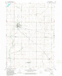
1979 Map of Fonda
USGS Topo · Published 1986About this map
Fonda serves as the primary hub of this 1970s topographic study, situated at the junction of the Illinois Central Gulf and the Chicago Milwaukee St Paul and Pacific railroads. This intersection underscores the town's historic role as a regional transport center for the surrounding agricultural landscape of Pocahontas and Calhoun Counties. The map reveals a transition in land use from the organized grid of the town center to the managed conservation lands of the Towhead Lake State Game Management Area to the south.
Find a feature on this map
23 named features on this map. Tap any name to fly to it.
Don’t see what you’re looking for? This feature index may not catch every label — zoom into the map to look around manually.
Map Details
Editions of this 1979 Fonda Map
2 editions found
Other maps of this area

1954 · Fort Dodge
USGS Topo · 1:250,000

1957 · Fort Dodge
USGS Topo · 1:250,000

1958 · Fort Dodge
USGS Topo · 1:250,000

1979 · Pocahontas
USGS Topo · 1:24,000

1979 · Varina
USGS Topo · 1:24,000

1979 · Fonda
USGS Topo · 1:24,000

1979 · Pomeroy
USGS Topo · 1:24,000

1979 · Newell East
USGS Topo · 1:24,000

1979 · Fonda NE
USGS Topo · 1:24,000

1980 · Lytton
USGS Topo · 1:24,000