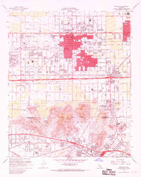
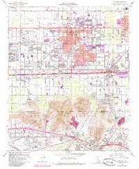
1967 Map of Fontana
USGS Topo · Published 1969About this map
The Steel Plant dominates the industrial landscape of the late 1960s, reflecting the era's heavy manufacturing prowess in the San Bernardino Valley. This survey reveals a transition from agricultural roots to a dense suburban and industrial corridor, anchored by the growing cities of Fontana and Rialto. The topography shifts dramatically from the urban grid in the north to the Jurupa Mountains and Pedley Hills in the south, where extractive industries like the Crestmore Quarry and Jensen Quarry are etched into the terrain.
Find a feature on this map
76 named features on this map. Tap any name to fly to it.
Don’t see what you’re looking for? This feature index may not catch every label — zoom into the map to look around manually.
Map Details
Editions of this 1967 Fontana Map
5 editions found
Other maps of this area

1896 · San Bernardino
USGS Topo · 1:62,500

1897 · Cucamonga
USGS Topo · 1:62,500

1898 · San Bernardino
USGS Topo · 1:62,500

1900 · Cucamonga
USGS Topo · 1:62,500

1901 · Southern California Sheet No. 1
USGS Topo · 1:250,000

1901 · San Bernardino
USGS Topo · 1:62,500

1901 · Elsinore
USGS Topo · 1:125,000

1901 · Riverside
USGS Topo · 1:62,500

1902 · Corona
USGS Topo · 1:125,000

1903 · Cucamonga
USGS Topo · 1:62,500