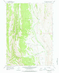
1967 Map of Fontenelle Basin
USGS Topo · Published 1978About this map
Bridger National Forest defines the western landscape of this Lincoln County survey, where high ridges run in parallel north-to-south alignments. The drainage of Fontenelle Creek dominates the central basin, joined by numerous named tributaries including Minnehaha Creek and South Fork Fontenelle Creek. This area is characterized by significant topographic relief, most notably at the Fontenelle Hogbacks and the sharp rise of Absaroka Ridge. While the territory is largely undeveloped, the map documents early resource exploration with drill holes situated near Little Bear Creek and specialized infrastructure like a Ditch and BR 7362 in the southern reaches of Mammoth Hollow. Geologists and researchers can trace the distinct ridgelines of Commissary Ridge and Oyster Ridge which dictate the flow of the local watershed during the late 1960s.
Find a feature on this map
36 named features on this map. Tap any name to fly to it.
Don’t see what you’re looking for? This feature index may not catch every label — zoom into the map to look around manually.
Map Details
Editions of this 1967 Fontenelle Basin Map
2 editions found
Other maps of this area

1936 · Cokeville
USGS Topo · 1:96,000

1942 · Cokeville
USGS Topo · 1:125,000

1945 · Fort Hill
USGS Topo · 1:62,500

1947 · Fort Hill
USGS Topo · 1:62,500

1955 · Preston
USGS Topo · 1:250,000

1958 · Preston
USGS Topo · 1:250,000

1962 · Preston
USGS Topo · 1:250,000
1967 · Pole Creek
USGS Topo · 1:24,000

1967 · Devils Hole Creek
USGS Topo · 1:24,000
1967 · Wilkinson Creek
USGS Topo · 1:24,000