1969 Map of Fontenelle
USGS Topo · Published 1984About this map
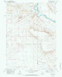
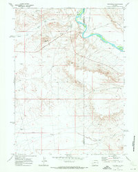
Green River waters define this high-desert corridor where the Lincoln Co Sweetwater Co boundary follows the river's winding course. This late-1960s landscape shows the transition from historic overland travel to modern water management, evidenced by the proximity of the Emigrant Trail and the Historical Site (Old Ford) to the engineered Fontenelle Aqueduct. The Fontenelle Townsite stands near the base of Slate Creek Butte, a prominent landmark overlooking the confluence of Slate Creek and the main river channel.
Find a feature on this map
17 named features on this map. Tap any name to fly to it.
Don’t see what you’re looking for? This feature index may not catch every label — zoom into the map to look around manually.
Map Details
Editions of this 1969 Fontenelle Map
2 editions found
Other maps of this area

1954 · Ogden
USGS Topo · 1:250,000

1954 · Rock Springs
USGS Topo · 1:250,000

1955 · Preston
USGS Topo · 1:250,000

1955 · Lander
USGS Topo · 1:250,000

1958 · Lander
USGS Topo · 1:250,000

1958 · Ogden
USGS Topo · 1:250,000

1958 · Rock Springs
USGS Topo · 1:250,000

1958 · Preston
USGS Topo · 1:250,000

1960 · Ogden
USGS Topo · 1:250,000

1961 · Lander
USGS Topo · 1:250,000