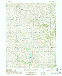
1985 Map of Ford City
USGS Topo · Published 1985About this map
Ford City serves as the primary settlement in this corner of Northwest Missouri, situated amidst a landscape defined by an intricate network of drainage ways. The terrain is deeply dissected by numerous watercourses, including Lost Creek, Sandy Creek, and Owl Creek, which have carved significant valleys through the agricultural uplands. A notable human imprint on the land is the abandoned Railroad Grade that cuts across the northern section, tracing a former transport corridor that once linked these rural communities to wider markets.
Find a feature on this map
17 named features on this map. Tap any name to fly to it.
Don’t see what you’re looking for? This feature index may not catch every label — zoom into the map to look around manually.
Map Details
Editions of this 1985 Ford City Map
This is the sole edition of this map. No revisions or reprints were ever made.
Other maps of this area

1923 · Clarksdale
USGS Topo · 1:62,500

1923 · Maysville
USGS Topo · 1:62,500

1925 · Clarksdale
USGS Topo · 1:62,500

1925 · Stanberry
USGS Topo · 1:62,500

1925 · Maysville
USGS Topo · 1:62,500

1925 · Darlington
USGS Topo · 1:62,500

1939 · Stanberry
USGS Topo · 1:62,500

1943 · Stanberry
USGS Topo · 1:62,500

1950 · Kansas City
USGS Topo · 1:250,000

1950 · Darlington
USGS Topo · 1:62,500