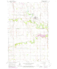
1963 Map of Fordville
USGS Topo · Published 1980About this map
Fordville sits at a strategic junction in northeastern North Dakota, where the Soo Line railroad crosses the landscape just north of the Forest River. This 1963 survey, photorevised in the late 1970s, captures the town's infrastructure, including the Fordville Airport and the nearby Oak Grove Cem. The geography is defined by the convergence of several waterways, including the North Branch, Middle Branch, and South Branch, which feed into the river system. A notable addition in purple revision is the Fordville Dam Normal Pool 1105, illustrating mid-century water management efforts. The map also delineates the boundary between Walsh Co and Grand Forks Co, cutting through township sections like Eden and Inkster. Numerous gravel pits and small industrial sites highlight the local reliance on the area's geological resources.
Find a feature on this map
20 named features on this map. Tap any name to fly to it.
Don’t see what you’re looking for? This feature index may not catch every label — zoom into the map to look around manually.
Map Details
Editions of this 1963 Fordville Map
2 editions found
Other maps of this area

1952 · Thief River Falls
USGS Topo · 1:250,000

1956 · Thief River Falls
USGS Topo · 1:250,000

1957 · Thief River Falls
USGS Topo · 1:250,000

1963 · Orr
USGS Topo · 1:24,000

1963 · Pleasant Valley
USGS Topo · 1:24,000

1963 · Fordville SE
USGS Topo · 1:24,000

1963 · Pisek
USGS Topo · 1:24,000

1963 · Fordville
USGS Topo · 1:24,000
1963 · Inkster
USGS Topo · 1:24,000

1967 · Thief River Falls
USGS Topo · 1:250,000