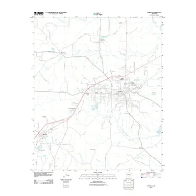
2011 Map of Fordyce
USGS Topo · Published 2011About this map
Fordyce serves as the central hub of this South Arkansas landscape, where the local road network converges at the intersection of several regional routes. The map documents a mix of developed town centers and outlying rural settlements, including the distinctively named Bucksnort to the northwest and Ebenezer to the southeast. The geography is defined by a dense network of waterways like Cooks Creek and Caney Creek, which feed into several managed reservoirs such as Lake Lansdale and Tri-County Lake. Local history is anchored by numerous burial grounds distributed across the area, from Oakland Cemetery near the heart of town to the more remote Stroud Cemetery and Mount Zion Cemetery. This survey captures the region as it transitions from the established residential blocks of North Fordyce to the timber-rich surroundings of Dallas County, providing a clear view of the area's twentieth-century expansion and its rural agricultural roots.
Find a feature on this map
86 named features on this map. Tap any name to fly to it.
Don’t see what you’re looking for? This feature index may not catch every label — zoom into the map to look around manually.
Map Details
Editions of this 2011 Fordyce Map
This is the sole edition of this map. No revisions or reprints were ever made.
Other maps of this area

1903 · Camden
USGS Topo · 1:125,000

1953 · El Dorado
USGS Topo · 1:250,000

1957 · El Dorado
USGS Topo · 1:250,000

1958 · El Dorado
USGS Topo · 1:250,000

1960 · El Dorado
USGS Topo · 1:250,000

1966 · Kingsland
USGS Topo · 1:24,000

1966 · Fordyce
USGS Topo · 1:24,000
1969 · Ivan
USGS Topo · 1:24,000
1970 · Fordyce NE
USGS Topo · 1:24,000

1973 · Bearden
USGS Topo · 1:24,000